Sunday, January 30, 2011

Vintage photos of Crucible Mine and the Crucible Ferry!!!


Just got these from my good bud,Ed Begovich (long time SWPARE supporter!)More treasures from the Begovich archive! These beatuiful shots of the Crucible Mine and ferryboat Nekoda were taken by his Grandpap Frank Begovich.I estimate these from the mid to late 1940's judging from the cars.Ed says he has more on the way,so keep checking back!!
One bummer,though.Ed's Dad actually witnessed the scrapping of the Nekoda (and may have pics to prove it)So.looks like I'll need to find a new mystery!! Oh,well...enjoy these awesome pics....more soon.Thanks,Ed...again!!

More classic shots from Lock 6,Rices Landing,Pa


Two of these pictures are from during a flood on the Monongahela river.I estimate these shots from the late 1950s,but my Dad will know for sure.The non-flood shot is facing the lock and dam from the north.The beach area is no longer there and appears black because the "sand" looks more like coal/slate washed up from the river bottom.

More Classic Pittsburgh Riverboats!


Now, I don't have as much info on these riverboats as Evan did on his recent post, because these are old pictures of older pictures.These shots of the riverboats Homestead and Duquesne seem to be from same time period.Both seem to be owned/operated by the Carnegie-Illinois Steel Corp.Any additional information is always welcomed!
In my Grandfathers films,I found some 16mm footage of another riverboat in the icy Monongahela.I plan to post as soon as I get the films digitally scanned.Stand by river fanatics...more to come!

Saturday, January 29, 2011

The Nemacolin, PA Ferry 1917-1949

The Nemacolin Ferry was first put into operation in August, 1917,  used to haul materials, passengers and wagons from Huron Station, located across the Monongahela River. The original ferry was constructed of wood and propelled by a steam engine. In its first year, it would haul approximately 25,000 wagon loads of various materials across the river for the mine. A new steel cable was required every 45 days to keep the ferry in operation.

The ferry in use with help from the Buckeye Coal Co. motorboat.

The Buckeye Coal Company motor boat.


In November of 1924, the Nemacolin Ferry sank and an entire new flat had to be built. The new ferry was put into service on December 20, 1924.

Ferry flat out for repairs.


Starting in mid-1926, grading of the road from the Ronco intersection to the bridge at Brown's run was completed. This would allow an outlet from the Nemacolin Ferry to to the road that connected Ronco and Masontown. The road on the fayette county side would eventually be open to vehicles in October of 1928. The bridge over Brown's Run was completed later in the same year (1926). The Buckeye Coal Company completed both the bridge and the road west of the bridge to the ferry landing. The eastern road to the ferry landing was completed the following year(1927), allowing better access to Fayette County.

Ferry Road.

Construction of retaining wall along Ferry Road.

Grading of road to Nemacolin Ferry from Big Tree.


A new steel ferry boat was built by Midland Barge Company of Midland, PA and towed from Midland to Nemacolin. The new boat had the capacity to carry 14 tons, weighed 64,000 lbs, and cost $5600. It was received on June 12, 1931. In 1935, the ferry's aprons were removed and redesigned to accomodate for the heavy trucks that were now using it frequently. The ferry was briefly taken out of service from May 1945 to June 1945 to receive a reconditioning.

The steel ferry boat.

Nemacolin ferry.  Ronco, PA and the former water plant on the opposite shore.


On January 1, 1949, the ferry was taken out of operation by the Buckeye Coal Company and sold to Kenneth Forsythe of Carmichaels, who would then operate it himself. Other operators were Hugh Christopher of Adah and Frank Yandura of Carmichaels.


Information and pictures courtesy Nemacolin: The Mine - The Community, by Robert A. Korcheck.
And Robert Snopik.

The Movie "The Road" and a filming location question. Fayette County, PA

Ok, this will be quick....ever since I saw The Road a year or so ago, I was fascinated w/ the locations it was filmed at locally.  I felt sort of, you know, connected 'cause they used the big waste pile in Buckeye...

A blog author in a gratuitous shot

I even watched them film a portion there once. The dump was shown during a storm scene featuring the derelict, Robert Duval.

Robert Duval at the Nemacolin Slate Dump

Area of above scene


I also felt sort of, you know, connected  to the movie 'cause I had been to and biked on yet another location used for filming, the 11 or 12 mile stretch of the abandoned PA turnpike.  Not a lot of people even know about that nearby road....can be seen in Our Pennsylvania Turn Pike Blog


An author in yet another gratuitous shot


You can see the tunnel behind the bad guys.


In real life.....


....in movie life....

Then one day, Dr Weimer and I were riding our bikes on the then uncompleted Rt 43 turnpike, south of Uniontown, heading into WVa, and we noticed a jack knifed big rig on a newly completed, yet unopened bridge.  No one was around and we both thought it was odd that a rig was like that, in May, on an unopened road was stranded like that.  I didn't have a camera that day, so I didn't take a shot.
Then, about a year and a half later, I saw The Road, and it all made sense.  Directly after watching, I called Weimer from the lobby and said '"Remember that day............"


So, when I watched The Road for the first time, I noticed a scene that looks like it was filmed close by to me in Greene County, most likely Fayette County, PA, that I am having trouble locating. 


(thanx to young Danielle and her limitless free time for re-watching movie and capturing shot last night!)


You can see on the left side the waste pile in Buckeye, so I figure this should either be in Ronco, Gates or Palmer, Fayette county.   Or it could be all that Hollywood magic stuff they talk about and they superimposed the waste pile into another shot.


     Any Ideas?


Also, check out my trip the abandoned PA Turnpike in this blog.


Thursday, January 27, 2011

Fredericktown, PA riverboat J. L PERRY or W. P. SNYDER JR Circa 1948

     Today, I scanned a bunch of old pictures for an upcoming blog.  I'm still waiting for some more before I can do a proper post, but I found this one in the mix and thought it would fit in with the winter season and my recent winter rails to trails walk blog.

      The date on the back read 1948.  The picture was taken from the Fayette County side of the Monongahela river opposite Fredericktown, PA. Note the ice covering the river.  The waste piles of the Clyde mine can be seen in the background.
More coming soon, we promise.


Click here  or on  this other interesting one to see two brief histories of the steam boat above.

Chip just posted some more riverboat pictures here!

These two informative E mails came to me today about the boats history.


Evan,
   The W.H. Clingerman (launched under that name on February 21, 1918) was renamed the J.L. Perry in May, 1938.  In the spring of 1945 she was renamed the A-1.  That fall the Crucible Steel Company of America bought her and renamed her W.P. Snyder, Jr. after the president and CEO of the company.  She towed her coal barges to Crucible’s plant at MidlandPA and in 1954 she was laid up. (Due to competition from diesel tows, she saw less and less work.)

  She arrived in Marietta under her own steam on September 16, 1955, was shut down for the last time, and has been in permanent residence here at the Ohio River Museum, leaving occasionally for repairs.

  I hope this helps.  Thank you for your interest.  We are very proud to have the W.P. Snyder, Jr. in residence here.  She is now on the National Registry of Historic Places.  If you ever have the opportunity, please visit the Ohio River Museum.

  Thank you, Glenna

Glenna Hoff, Educator
Campus Martius/Ohio River Museum

...and...


Evan,
  There were actually 2 boats named the J.L. Perry.  The picture of the J.L Perry that you have, with the 1948 date on the back means that this boat probably was the Allegheny originally.  It was built at Ambridge,PA in 1927.  The Carnegie-Illinois Steel Co. people renamed her in June, 1945 and called her J.L. Perry.  She was dismantled in 1957.
   I am sorry for the confusion. 
        Thanks,   Glenna

Glenna Hoff, Educator
Campus Martius/Ohio River Museum


As always, click on the picture to enlarge.

Sunday, January 23, 2011

A winter walk down the Rices Landing, PA rails to trails on the former Monongahela railroad line. Now with Crucible and original Dilworth mine and Gateway mine ruins visit.


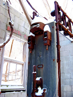
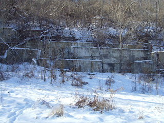
Yesterday was a snowy, cold day and I really didn't feel like doing a whole lot, so I  bundled up and headed to Stan-Lee's in Crucible for a bowl of Chili.  The night before I discovered the beauty of BING maps and their far superior quality as opposed to the Google Earth maps I've been using for years.  As I studied the maps in between Michelob beers (in cans), I noticed a lot of things I have been missing as the Bing maps are actually aerial shots of all four angles of what you are looking at.  I noticed I had overlooked a few odd buildings down at the old Crucible mine site (the remainder where demo'd back in 2006 or so, as talked about in this rather rambling catch all blog entry.  It had just snowed a day and a half earlier so I knew it would make for some pretty shots.  I trekked on past the actual now flat "reclaimed" mine site, I walked behind the bulldozed giant piles of mine waste and there they were, the only two buildings remaining from the Crucible mine.  Now I had read a few weeks back that they left two buildings because of their sound condition and historical impact, but I was sort of let down w/ what was found.
Nothing to blow my skirt up
Tipple ruins


Remains of a mine building
The waste pile across the river has an almost exotic quality to it in winter.
Being cold out, but also incredibly clear, I decided to head to Rices Landing and walk on down the Rails to Trails that is built on the former Monongahela railroad.  Sometimes people ask me where we find all the points of interest that are the blog topics, and in this instance, I decide to blog about whats really easy to get to, easy to see, and we basically walk past all the time.

The steps are all that remain of the former Monongahela hotel in Rices Landing.


Under this overlook point, under all the mine waste lies a bank of old coke ovens.


I must have been the third or so person on the trail since the snow, and going was slow.  I walked on down towards the Greene Cove boat club, the trails end and stopped at the remains of the old, orginal Dilworth mine site.  I was told by an old timer at the barber shop that his father was one of the last men who worked here and that it was taken out of service in the  1920's.  In the summer, as we walk and bike thru here, its basically invisible in the overgrowth, so this was a great day to explore....Or was it the Emerald Mine?
A blog viewer corrected me as to this being the Gateway mine site.  The Dilworth (original site) was closer to the Rices Landing trail head.


That is, I believe where the coal came out and into the tipple.


Where coal from above shot used to go.  This tipple was demo'd a year and a half ago.


And this is what it used to look like.  As they were building the trail years ago, there were still steps attached and I climbed up into the tipple, Very cool and it didn't feel to dangerous. I of course had no camera w/ me then.


In case you wondered, this is what the above Gateway mine looked like


For a nice interactive birds eye map of the area, when the barge load out was still intact CLICK HERE.  Use the controls on top to zoom and rotate map.


Tipple destruction.


Old cast iron rail road marker along the trail
Another shot of the fenced in area where the shaft was located.


The original Dilworth mines deep shaft entrance.


Steps that led to the train station in Rices landing, they pass under the former tracks.
Old retaining wall.

For some more cool Rices Landing pictures, check out Chip's (the Rices Landing Kid) blog on some neat forgotten stuff!